Friday, June 28, 2019

Table Rock Trail @ The Balsams


Table Rock at The Balsams
On a second-in-a-row hot summer's day, we boarded The Rig and headed to Canaan, Vermont. We stopped in at Screw Auger Falls in Grafton State Park and then drove out to Upton, Erroll NH, and Colebrook NH and finally landing in Canaan. Driving through The Balsams area I noticed five hikers stepping out from a trail head–one of the hikers was a dog. This trail head is a just 1/8th of a mile from the Balsam's resort, so I figured it may have good views. While eating lunch at a rest stop just before Canaan, I searched for the trail.  Only a 2-mile round trip hike with views, I figured this had to be spectacular. And it was.

I couldn't get all the way out on Table Rock itself because of Bailey. The sheer cliffs could prove to be dangerous if a bee stung him or if something or someone jumped him. Nevertheless, we got close enough as you'll see from the photos. What a great find.

Co-pilot ready

On trail...
From Table Rock
Table Rock


Trailhead sign


Dodging storms on Whitecap

The Mahosuuc Range and the Presidential Range from Whitecap

We have hiked Whitecap Mountain in Rumford an average of once or twice a week all year long for the past 8 years. I love hiking Whitecap in the late fall when the first snow begins to fall. That's happened to us a couple of times over the past 8 years. Last year, we hiked on the afternoon of the first big snowstorm of the year. Descending the mountain in a light snow is exhilarating. I also like timing a hike in the summer when thunderstorms build in the Mahosuuc Mountain range. No, I don't have a death wish or think I can dodge lightening, but I love to watch the clouds build through the western hills. If a storm starts to percolate... we're out of there.

Yesterday, we hiked through light rains and intermittent sunshine with temps in the 80s. Several storm clouds swirled around the mountaintop but never materialized. These moments in the woods are when I feel most alive and an integral part of nature.


Mt Washington high above the western mountains. 
After the hike--he had a slew of swims

Trails.com map of my hike on GPS... we were a bit slow today. 
  

Tuesday, June 25, 2019

Hiking Trail 728

I used my hiking app to record my lawn mowing here at home. I'm sure I have better things to do with my time, but I guess I don't care. Even though my mowing looks disorganized, I can assure you that I went back and forth, up and down (with a couple of quick breaks) in orderly fashion. As a result, the notion that my mowing is haphazard is inaccurate.

Overall time: 68:44 
  

Monday, June 24, 2019

Wright Trail jaunt

One of many water falls on Goose Eye Brook along the Wright Trail
With the temperatures hitting 80s, it made sense to hike part of the Wright Trail in Newry. Wright has a canopy of trees for miles and parallels the Goose Eye Brook. This trail summits on the AT and its trail head is just past Frenchman's Hole, a well-loved swimming spot with cliffs and the crisp waters of the Bull Branch River. We did 2.2 miles out and back, and Bailey took a dozen swims.


Saturday, June 22, 2019

Exploring Jackman, Greenville, Moxie Falls...

Attean Pond, named after a River Logger that died on the pond
who once guided Henrry David Thoreau in the 1853.
Click on the picture

I've visited Jackman and in the 1990s and early 2000s during the winter season. They seemed smaller back then. Plus, I was on a mission. This time I did a lot more exploring. We stayed overnight at the Big Squaw ski area. This massive place went out of business several years ago and a groups of locals folks, Friends of Big Squaw, raised money and volunteered. I'd never paid much attention to the Kennebec River in years gone past or in Greenville or Jackman, but the towns are thriving in the summer time with tourists and sportspeople.

Riding shotgun
Big Squaw


Attean Pond
 

Above Moxie Falls

Moxie Falls


Mt Kineo

Morning at the ski area.  

Falls on the Old Canada Road heading to the Border Station

The Rig and Attean Pond. 

View from top of Baker Mountain

Baker Mountain, Bingham, Maine #10


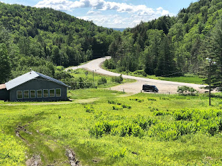
Baker Mt. Lodge
After overnighting in the Greenville area and exploring Mt. Kineo, we headed home. On the way up, we passed Baker Mountain in Bingham and decided to climb it on the way home. I love the idea of this little mountain with reasonable steeps and a quick T-bar. I can see how this tiny lighted gem could, like Spruce, Black, and Scottie's from the 1950s, help youngsters earn their skiing legs. Remember to click on the photos to enlarge. 

Lodge 
View from 1/4 of the way up. 
Safety hut at the top.


View from the top

Thursday, June 20, 2019

Hiking Glassface in Rumford

Glassface Summit... Western view up the Androscoggin River
Remember to click on the pictures to enlarge. 
We headed off on a warm Wednesday afternoon to do the quick hike up Glassface in Rumford Center. Within the first 10 minutes I had a half dozen ticks crawling up my pant legs. We met up with a mother and son and they too were battling the ticks. By the time the hike was over, I suspect I removed 24+ ticks and then through the evening combed more out of Bailey's fur. He's on NexGard, so when the tick bites him, it gets drunk and then dies.


Swimming the Scrogg

At home I discovered these little things beneath a flap on my hiking pants. 


Eastern View


1.6 miles